
Power flushing in Nuneaton
 Nuneaton is the home town of PowerflushUK and we have been cleaning out rust and sludge in heating systems here for over twenty years now. If you have heating or hot water problems why not give us a call first. We are specialists with thousands of flushing jobs done across the country.
We offer cleaning out limescale in your heating systems in these postcode areas:
CV10
CV11
CV13
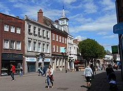
Now a bit of history about this lovely place to live. Nuneaton is a large market town in northern Warwickshire, England, near the boundaries with Leicestershire and the West Midlands. With an estimated population of 91,334 in 2020, it’s the largest town in Warwickshire. The town is known for being the birthplace of author George Eliot, who depicted Nuneaton in her novel “Scenes of Clerical Life.”
History:
- Originally known as ‘Etone,’ Nuneaton’s history dates back to a small farming settlement by the River Anker.
- In the 12th century, the Beaumont family took over, and a Benedictine nunnery was established, leading to the town’s renaming as Nuneaton.
- Nuneaton received a market charter in the 12th century, growing into a market town.
- The Battle of Bosworth occurred nearby in 1485, and King Edward VI School was founded in 1552.
- The town’s population grew steadily from 1543 to 1740.
Industry:
- A silk ribbon weaving industry developed in the mid-17th century, thriving for nearly two centuries before declining due to cheap imports.
- Coal mining was another major industry, growing with the industrial revolution and the development of transportation like canals and railways. The last coal mine in Warwickshire closed in 2013.
- Other industries included brick and tile production, brewing, hat and leather goods production, and engineering.
Civic Engagement:
- Nuneaton had a local board of health established in 1848, and it became a municipal borough in 1907.
- The town merged with Bedworth Urban District in 1974 to form the Borough of Nuneaton and Bedworth.
World War II and Postwar:
- Nuneaton was heavily bombed during the Blitz, with significant destruction in 1941.
- Postwar redevelopment included a masterplan for the town centre, and the town continued to grow with the construction of council and private housing.
Geography:
- Nuneaton is located near Coventry, Birmingham, Leicester, and London.
- The town is bisected by the Anker River and has been prone to flooding, though a flood relief channel was constructed in 1976.
- Nearby towns include Bedworth, Atherstone, Hinckley, Tamworth, Rugby, Coleshill, and Lutterworth.
Nuneaton’s rich history, industrial heritage, and growth through the centuries have shaped it into a significant town in Warwickshire, with a blend of historical landmarks and modern development.
